
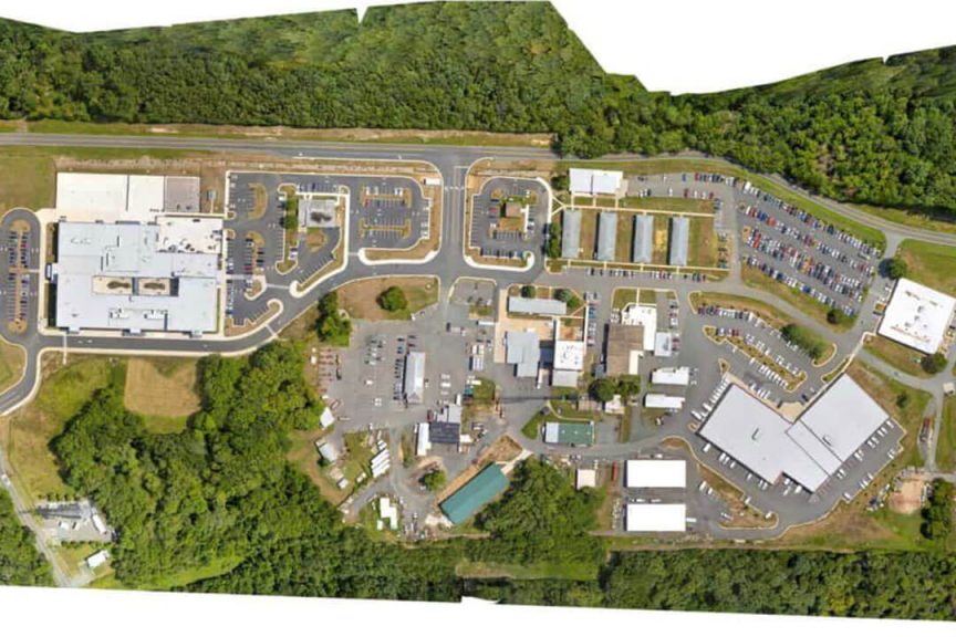
An orthomosaic map is a map composed of orthoimages - aerial photos that have been corrected for lens distortion, camera tilt, perspective, and topographic relief, which is changes in the elevation of the earth’s surface. A simple unprocessed aerial photo contains inherent inaccuracies because of distortion.
To guarantee that the borders of these pictures completely align with one another, stitching together hundreds of orthoimages requires further orthorectification. The idea is to make geometric corrections to the images to give the impression that the orthomosaic image was captured from an infinitely high vantage point.
How is it created?

The orthorectification process is essential for creating orthomosaic maps. This is the process used to eliminate the image's perspective and terrain-related distortions. To create an orthorectified image, you need to start with a couple of elements:
- A georeferenced image
- A digital elevation model (DEM)
- A camera model or rational polynomial coefficients (RPC)
The georeferenced image is a raw aerial image where each pixel has been associated with a location based on a global geodetic coordinate system. These are then matched to the relief of a DEM where each point is also georeferenced.
The camera model is essentially a generic equation used by camera sensor manufacturers to determine the connection between image space and real object pace.
An orthorectified image is created by combining all of these elements. Orthorectification is a complex mathematical process, and the majority of high-level applications take either of two possible methods. The first one, known as the "black-box" or "analytical model," modifies the RPC of the camera model to change the placement of features in an aerial image.
The physical-based approach is more complicated. This so-called rigorous model takes into account certain details about the camera sensor that are only accessible through its manufacturer, such as its electronic and optical characteristics, and how it reacts to atmospheric conditions.
GCPs or ground control points are essential to the orthorectification process. GCPs are selected points in the survey area from which ground-level measurements are made. High-precision GPS systems are used to determine the locations and elevations of these points. Then, using high-contrast markers, they are highlighted on the aerial image.
How Are Orthomosaics Being Used and Which industries use orthomosaic maps?

Getting an updated view of a large area of land is one of the main cases for an orthomosaic map. Your new development project could be finished, new construction projects could be underway, or the landscape could have changed from natural disasters. Whatever the reason is, orthomosaics are the most effective way to combine aerial images for an updated view of your land.
1. Real estate
An orthomosaic map that can be used to make accurate distance measurements is a very useful tool for real estate agents. When negotiating with potential clients, a high-quality orthomosaic map is a useful tool. The view shot from a drone shows off a property in a way that no photos taken from ground level can capture. Orthomosaic maps are also highly interactive, allowing potential clients to zoom in on certain details. On orthomosaic maps, even the surroundings are clearly visible.
2. Law enforcement and emergency response
Orthomosaic maps are becoming more valuable to police departments all over the world for documenting crime scenes and monitoring high-crime areas. A precise map can help in developing a tactical response, especially as they can reveal environmental features that may not be visible from at ground level.
Orthomosaic maps have also been used for crime scene prevention. A high-quality orthomosaic map provides an accurate snapshot of the crime scene that can be revisited indefinitely.
In disaster response, a quick fly-around with a drone is a risk-free way of assessing the damage post-disaster. Drone damage surveys can be completed in a fraction of the time it would take for responders to go over the area, which also protects people from unnecessary risks. Much like law enforcement, emergency responders who know the lay of the land can come up with a more strategic approach to resolve the situation.
3. Agriculture
Orthomosaics offer huge advantages to the agricultural sector. Multispectral cameras on specialized drones collect data from certain bands of light, including Red, Green, Blue, Red Edge, and Near-Infrared. The added data from multispectral camera systems along with the ability to generate orthomosaic maps allows farmers to get a detailed understanding of their vegetation health with an NDVI index. Using this information, they can treat areas that require immediate attention and have a more successful crop season.
4. Construction
Orthomosaics are also very helpful to construction companies. They may regularly receive updated images of their construction sites and they can leverage the accuracy of the orthomosaics for precise measurements. Users can measure distance, area, and volume using software tools like DroneDeploy. With the use of these tools, construction companies may estimate material prices, calculate the volume of stockpiles, and collect other useful information without physically being at the construction site. Software programs can also use the raw data from the aerial photos to construct 3D models, which is another powerful tool for construction firms.
5. Environment conservation
Monitoring critical parameters, such as the level of vegetation in an area, the level of water in a lake, and the movement of sand dunes in the desert, can be aided by a good orthomosaic map. Even the movement of wildlife can be monitored.
6. Urban planning
Urban planners and city engineers must ensure that the infrastructure of a city can handle the population of a city while also protecting against disasters. Having a highly accurate, bird’s eye view of the whole city allows urban planners to identify evacuation areas, lowlands that are prone to flooding, choke points in roads that can lead to traffic buildup, and areas with different zoning rules.
7. Others
Along with inspecting crops, orthomosaic maps are excellent for performing aerial inspections of equipment and other facilities. They can be used for inspecting rooftops, solar installations and buildings that are falling apart. Orthomosaic maps are sometimes used in legal cases too. Certain cases require updated and accurate imagery of a property in question. Orthomosaics provide the necessary imagery needed for the legal proceedings. Depending on the software or application you're using, You can use orthomosaics to count trees, monitor forest health, count cattle, determine the number of cars in a parking lot, see the supplies on a construction site, measure rooftops, make annotations and more.